LivingLab Datasets

Multirotor drone application in grassland management
Source: Estonian Grassland Management
Last update: 23-09-25
Commercial multirotor (DJI) drones with fitted photographic and video cameras can be used by farmers to monitor livestock and visually assess farmland from a distance to reduce the need for feet on the ground. Create compelling aerial images, videos, and orthophotomaps as communication and information/education materials between farmers, the public, and farm advisors.
IoT supported remote control of beehaves
Source: Smart Villages Network
Last update: 23-09-25
The solution represents remote control of the situation in remote beehives. It consists of an automated measurement system - an IoT-supported hive scale for monitoring honey production, temperature, and relative humidity. The scale also has a GSM modem for data transfer to the mobile phone of the user. Furthermore, the solution includes a refractometer for measuring water content in honey and a conductometer for measuring the electrical conductivity of honey. The technology helps the beekeeper to save time and the cost of transportation, and thus reduces CO2 emissions.
DSS In Irrigation System
Source: Organic Table Grapes
Last update: 23-09-25
In organic table grape management, irrigation plays a key role, more than soil fertility or control of pests and diseases. being a short cycle life crop, in which quality and quantity are fundamental for success, controlling irrigation, especially in the southern Mediterranean regions, it's fundamental for the standard that most of the cultivars have. Buyers are more willing to acquire a controlled irrigation product that can be better managed from a remote location. Finally, the water use efficiency increases, and the entrepreneur can also save money.
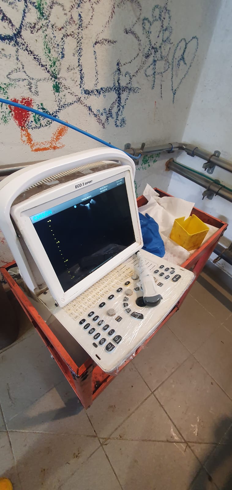
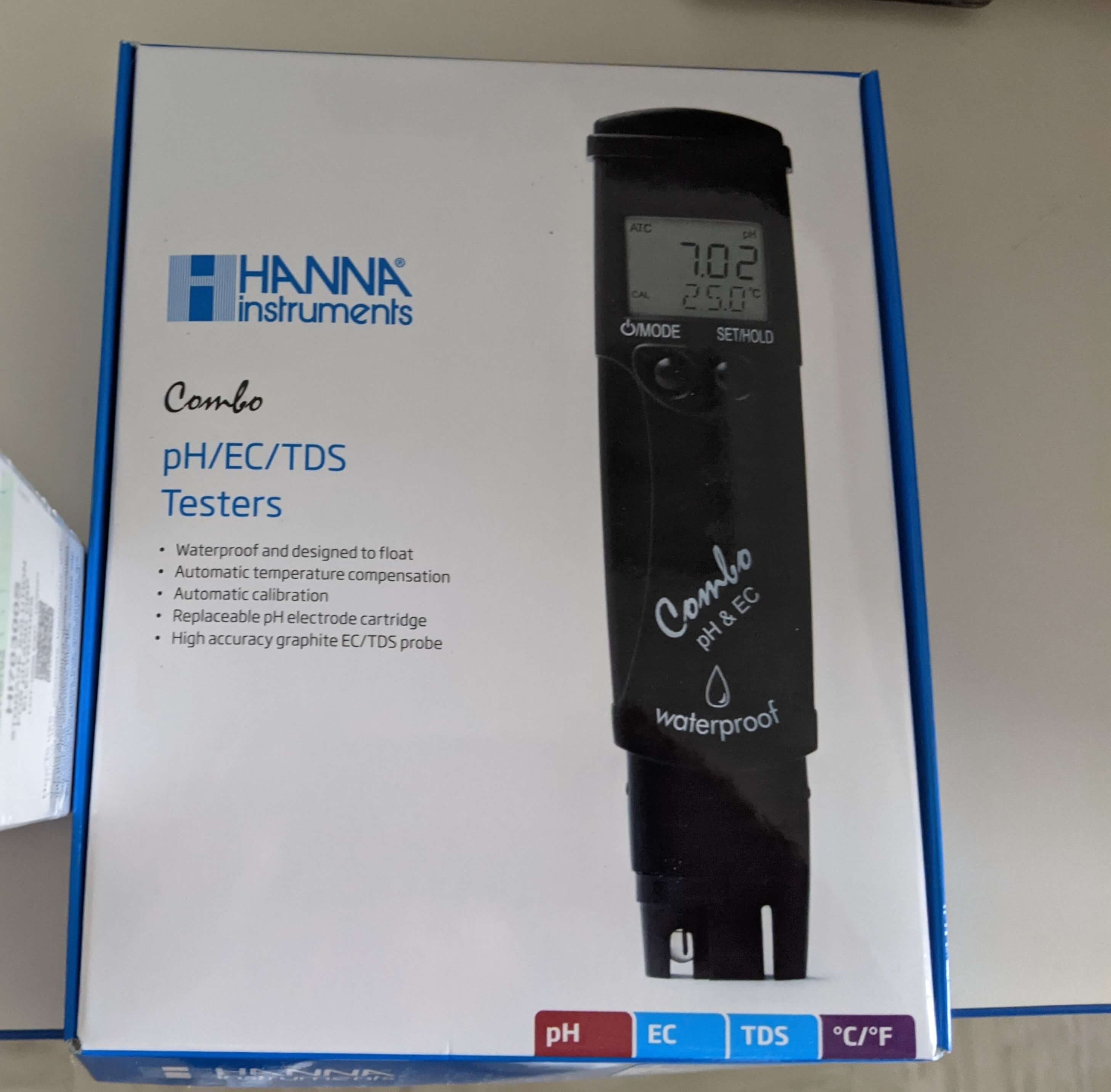
Ultrasound
Source: Consorzio Pecorino Toscano
Last update: 23-09-25
A veterinary ultrasound machine is a medical imaging device designed for animal healthcare. It uses high-frequency sound waves to produce real-time images of internal organs, tissues, and blood flow in various animal species. This non-invasive and safe diagnostic tool is commonly used for pregnancy detection, organ evaluation, and monitoring of medical conditions in pets, livestock, and wildlife.
Pet scan bluetooth
Source: Consorzio Pecorino Toscano
Last update: 23-09-25
A Bluetooth animal reader is a portable electronic device designed to wirelessly scan and identify animals equipped with microchips or RFID tags. It uses Bluetooth technology to transmit scanned data to smartphones, tablets, or computers in real time, allowing veterinarians, pet owners, and animal researchers to efficiently track and manage animal information. These devices are commonly used in pet identification, livestock management, and wildlife monitoring, offering a fast and reliable way to access and store animal records.
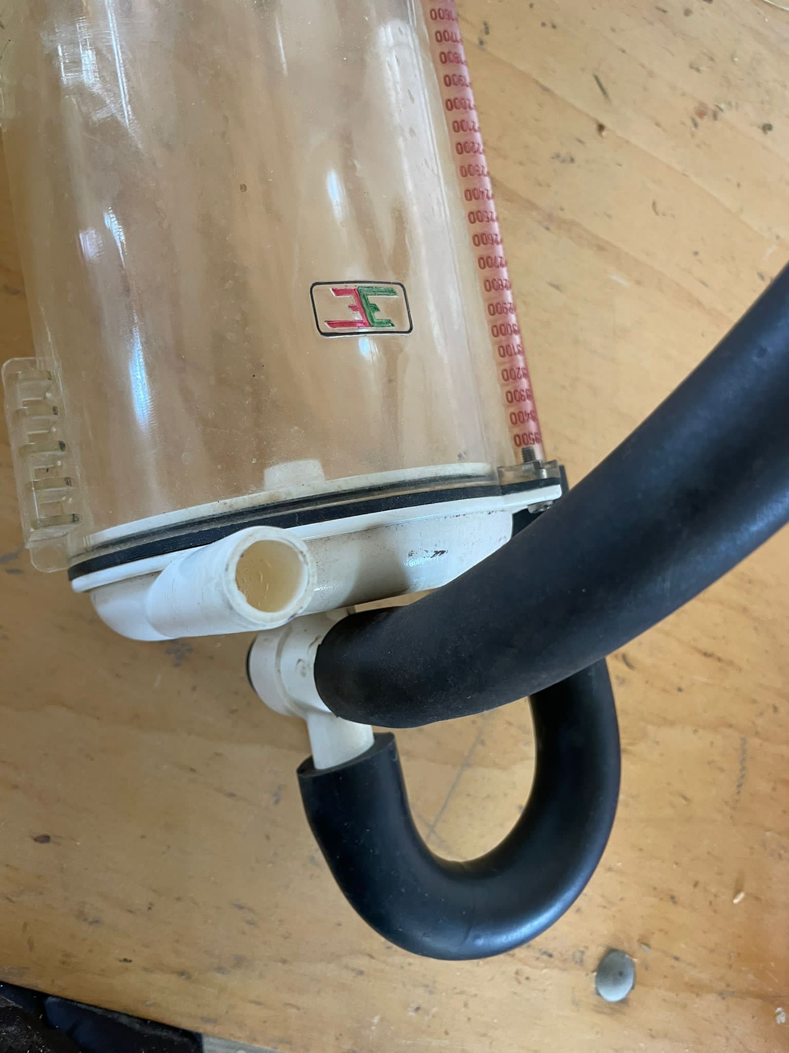
Milk meter
Source: Consorzio Pecorino Toscano
Last update: 23-09-25
A milk flow meter is a device used in dairy farming to measure the volume of milk during milking. It is typically installed in the milking machine system, where it monitors and records the amount of milk extracted from each cow during a milking session. The meter works by detecting the flow of milk through a sensor, which can be based on different technologies such as ultrasonic, electromagnetic, or mechanical systems. This data is then used to assess the milking performance, ensure optimal milking efficiency, and monitor the health and productivity of dairy cows.
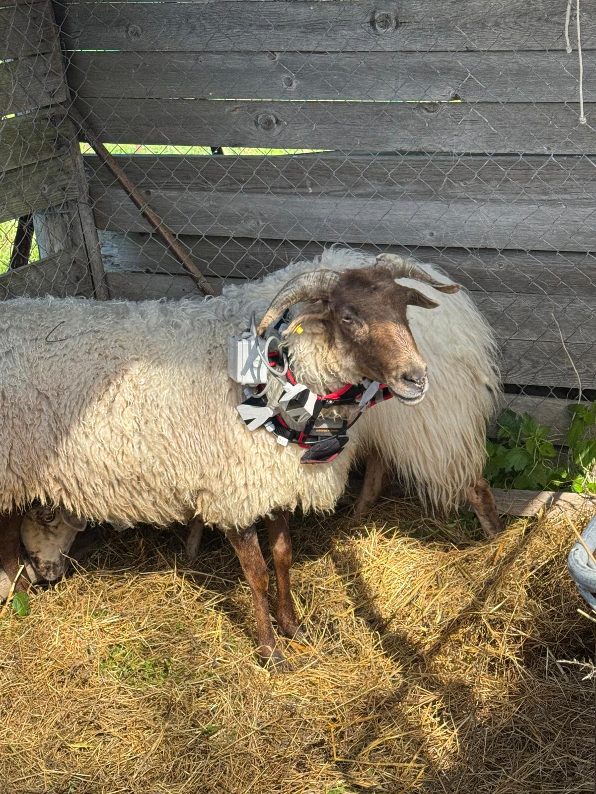
Smart collar
Source: Consorzio Pecorino Toscano
Last update: 23-09-25
Smart collars for animal tracking are wearable devices designed to monitor and track the position of animals in real-time. These collars are equipped with GPS, RFID, or Bluetooth technology to gather location data, which is transmitted to a central system, smartphone, or computer for analysis. They are commonly used in pets, livestock, and wildlife management. The collars are often lightweight, waterproof, and designed for comfort and durability, making them suitable for long-term use. Smart collars can provide valuable insights into animal behavior, health, and movement patterns, helping owners, farmers, or researchers monitor the animals' activities, prevent lost animals, and enhance management decisions.
APP Poderi
Source: Consorzio Pecorino Toscano
Last update: 23-09-25
Poderi is a digital platform aimed at improving farm management by providing tools for tracking and managing livestock, crops, and agricultural resources. The app offers a range of features, including real-time monitoring of animals, field management, and record-keeping for daily farm activities. It enables farmers to manage their operations more effectively by providing insights into animal health, productivity, and behavior. The app can integrate data from various sources such as GPS tracking systems, sensors, and farm equipment, offering a comprehensive overview of farm performance. Poderi helps farmers make data-driven decisions, optimize resources, reduce waste, and improve overall productivity. Additionally, it provides a user-friendly interface for easy access to farm data, making it accessible to users with varying levels of technical expertise. This app integrates all data from technologies: ultrasound, Bluetooth pet scan, gate, milk meter, smart collar, software for ratio, and a portable device for quality of feed.
NDS software
Source: Consorzio Pecorino Toscano
Last update: 23-09-25
NDS (Nutritional Decision Support) software is a specialized tool designed to help farmers, veterinarians, and animal nutritionists formulate and manage optimal rations for livestock. The software uses advanced algorithms to calculate the nutritional requirements of animals based on factors such as age, weight, breed, production goals (e.g., milk, meat, eggs), and environmental conditions. It helps in balancing the animals’ diet to ensure they receive the right amount of nutrients, including proteins, carbohydrates, fats, vitamins, and minerals. NDS software integrates data from various sources, such as feed ingredients, animal performance, and farm conditions, to create precise feeding strategies. It also allows for monitoring and adjusting diets over time to improve animal health, productivity, and feed efficiency. By using NDS, farmers can optimize their feeding programs, reduce feed waste, and ensure better economic returns.
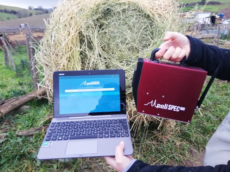
Polispec
Source: Consorzio Pecorino Toscano
Last update: 23-09-25
Polispec is a reflection spectrophotometer equipped with an internal lighting system and automatic reference settings, featuring extremely compact dimensions. Available in various spectral configurations ranging from 580 to 1080 nm, which spans from the end of the visible spectrum to the beginning of the near-infrared range, Polispec LITE is designed for both portable use and in-process installation. The Polispec allows the operator to directly assess the nutritional characteristics of forages and concentrates in the field.
Innovative Soil Scanner System
Source: Innovative Soil Scanner Technology for Sustainable Agriculture
Last update: 23-09-25
The Innovative Soil Scanner is a comprehensive system designed to assist farmers in optimizing nutrient management through fast, reliable, and affordable soil analysis. The system includes a NIR sensor, mobile data upload to the cloud, and a mobile app that provides real-time, site-specific soil nutrient information. This technology helps reduce fertilizer use, minimizes environmental impact, and enhances cost-effectiveness through data-driven decisions for sustainable farming.

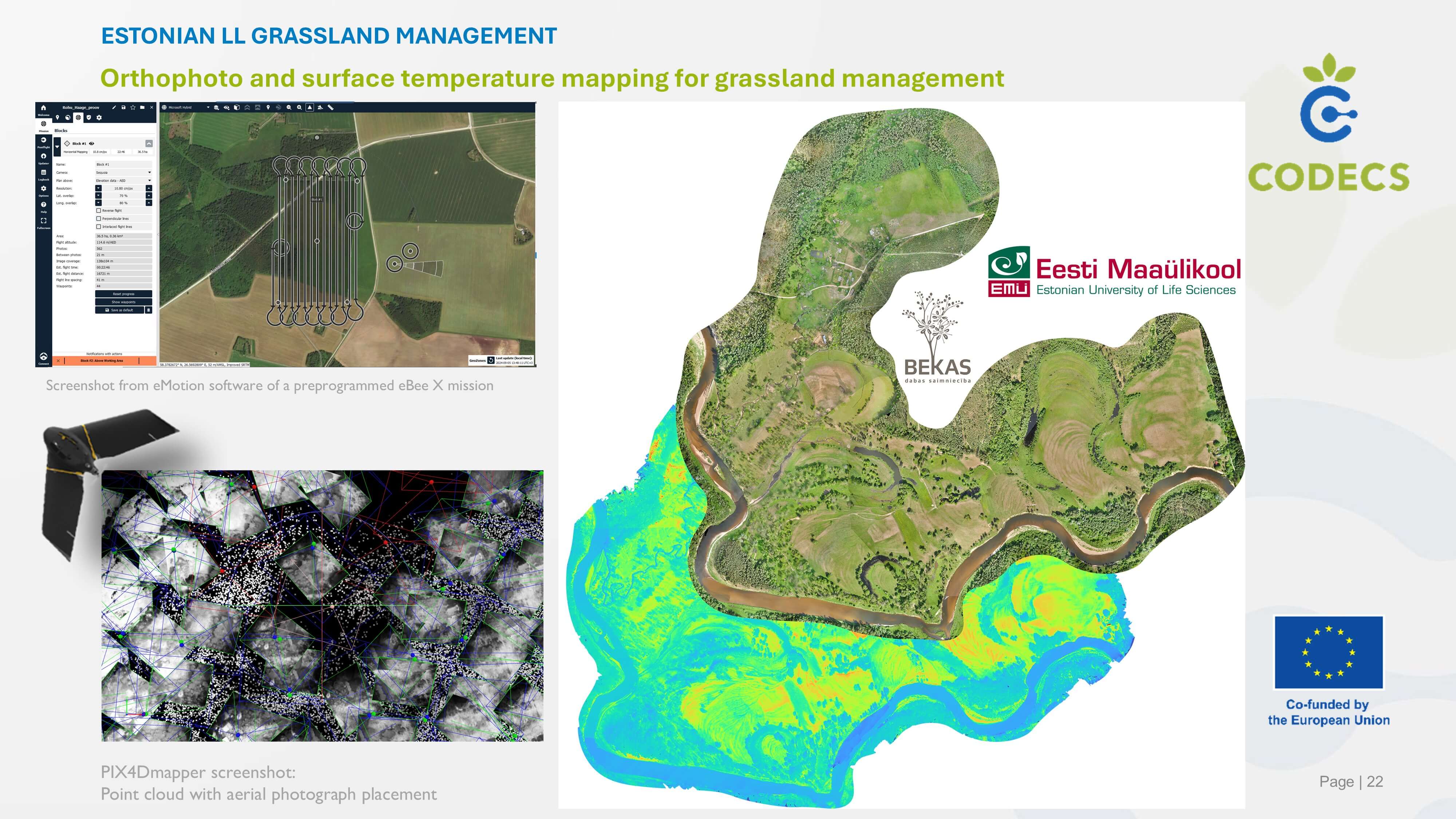
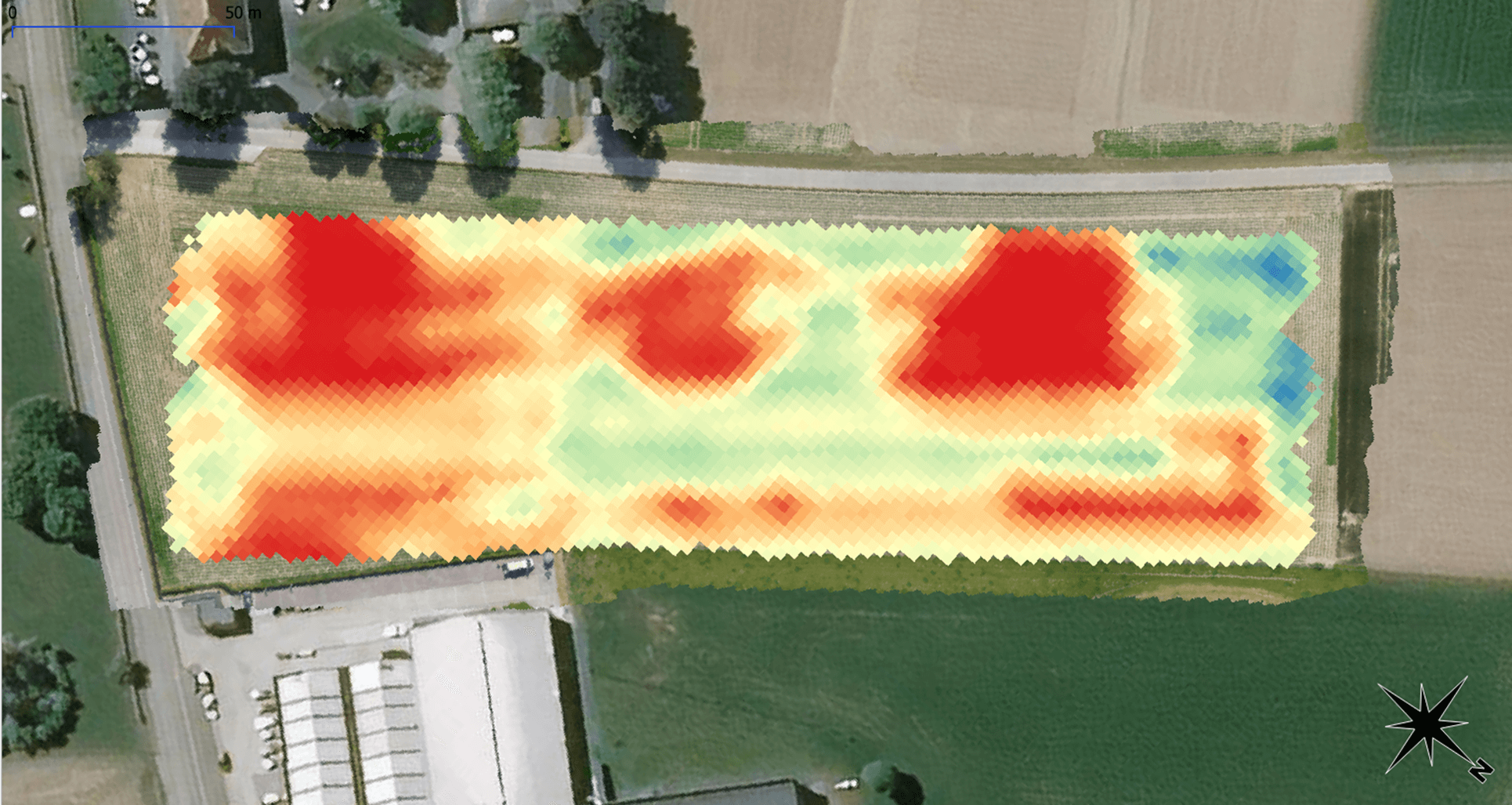
Orthophoto and surface temperature mapping for grassland management
Source: Estonian Grassland Management
Last update: 23-09-25
The EbeeX fixed-wing drone is equipped with a dual RGB/thermal mapping camera rig operated by a professional remote sensing team/pilot to create high-resolution orthophoto and surface temperature maps of grasslands managed by livestock farmers. Farmers use such digital maps to plan grassland management and as communication materials; maps are also passed on to researchers and grassland specialists for further habitat assessment.
APPETIT platform
Source: APPETIT Living Lab
Last update: 23-09-25
The APPETIT platform is a digital marketplace connecting local food producers directly with consumers, eliminating intermediaries. It enables individual farmers to set prices, transact online, issue invoices, and access collaborative logistics, marketing, and support. By automating intermediary functions, APPETIT boosts market efficiency and scalability, benefiting farmers, consumers, and stakeholders in a geographically defined area. Revenue from transactions funds ongoing improvements and user-driven functionalities.
Virtual farm tours
Source: Low cost and no cost digital platforms
Last update: 23-09-25
A virtual, interactive farm tour of the living lab demo farm. It provides a range of audio, video, and text-based resources about the farm and the digital technologies used.
Digital irrigation management system that integrates multiple technologies to enhance water management and optimize irrigation processes
Source: Artificial irrigation management system
Last update: 23-09-25
The Slovak Living Lab is enhancing Irriga Global and Valley irrigation management systems by developing a data collection and analysis methodology based on real-time sensor data. The system integrates soil moisture sensors, weather stations, and IoT devices to optimize irrigation decisions. While AI/ML algorithms are not yet implemented due to data limitations, the collected data will serve as a foundation for future automated and predictive irrigation management.
PigLink
Source: LIT OUESTEREL
Last update: 23-09-25
Starting point: Digitalization in pig farms is evolving, and the use of connected tools is increasing. However, the multiplicity of management boards and the need to sometimes register the same data twice in different software make this digitalization a bit inefficient. There is a need to facilitate data registration and sharing. Objective: PigLink aims to facilitate data sharing between equipment in farms and management software, to ease the farm management and traceability to reinforce food safety and quality control, from farm to consumer. How it works: PigLink is a platform for sharing standardized data between authorized partners of pig farmers, using web API’s - At the start: o Farmers register themselves on the platform, describe the structural elements of their farm (buildings, rooms, pens), each identified by a unique “PigLink number” o Equipment manufacturers register their equipment o Farmers link their equipment to the structural elements of their farms - Once it is set up: o Data user asks PigLink for data from a given field (feed, ventilation, water, …), for a farm o The data user and data provider must first sign a data exchange agreement o Piglink checks if these data are collected on the farm, and whether there is a consent agreement, and sends data to the user, provided that the farmer has also given their consent. Price: PigLink is free to use.
Individual milkmeter
Source: Occitanum OL Sheep
Last update: 23-09-25
Connected individual milk meters for dairy sheep represent a significant advancement in digital agriculture. These systems allow farmers to accurately and efficiently monitor the milk production of each animal, which is crucial for optimizing herd management and improving profitability. Individual milk meters are often associated with automatic feeders in the milking parlour. This allows the farmers to adapt the amount of feed distributed regarding milk production.
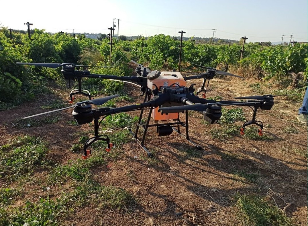
Spraying UAVs
Source: AUA Spraying Experimentation Demo Farm
Last update: 23-09-25
The use of unmanned aerial vehicles (UAVs) equipped with a spraying capability is being employed. These vehicles incorporate numerous digital technologies in their implementation pipeline, including, but not limited to, geospatial information systems (GIS) for flight planning, various environmental sensors connected to Internet of Things (IoT) stations for the constant monitoring of weather conditions, navigation sensors such as LiDAR sensors for altitude adjustments during spraying, and vision systems for obstacle avoidance. Subsequently, the data is analysed using image analysis techniques to obtain qualitative data on the spraying applications, or via laboratory retrieval of spraying tracers for the assessment of spraying displacement (drift).
Stenon FarmLab
Source: AgDiBi
Last update: 23-09-25
In the German LL, our focus lies on developing and establishing an educational program on digital technologies in crop production, and not so much on testing or implementing a specific technology. For process modelling, we have been discussing with our stakeholders on technology (Stenon Farmlab), which has also been considered in our outreach and education activities. The Stenon FarmLab is an integrated hardware and software solution for real-time soil analysis. The system consists of several components. These include a measuring device, which is equipped with various optical, electrical and climate sensors. The measuring device can be connected to an internet-enabled end device (e.g. smartphone) via WiFi and also uses an integrated GPS module for self-localisation. Measurement data collected is then transferred to a cloud solution where it is processed on-demand. The developed AI then calculates the individual contents of the following parameters from the sensor measurement data: NO3, Nmin, Ntotal, PO4, K, Mg, Corg, soil moisture, pH, soil temperature and soil texture. Once the calculation is complete, the results are saved and assigned to an user account and ready for further use to support the fertilization process of the farm."
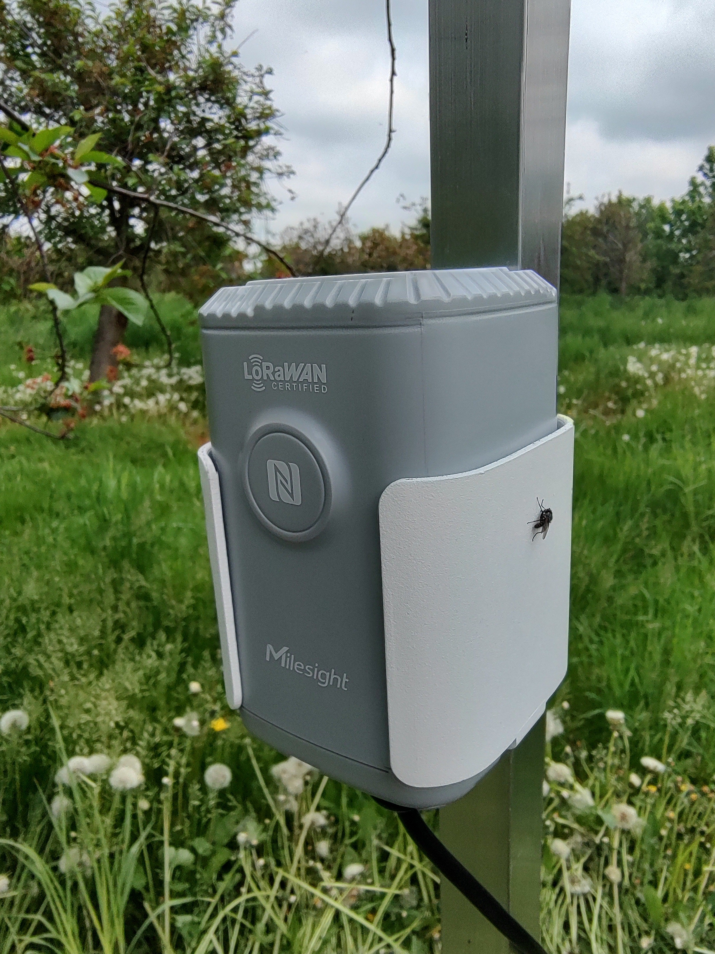
Monitoring of environmental variables
Source: Automation of Orchard Management
Last update: 23-09-25
There are 4 IoT sensors for monitoring of temperature and humidity of air (EM300-TH) and soil (EM500-SMTC) in the orchard at 4 different places. These sensors send data to the data platform, and the farmer can see the data in tables and graphs. It is necessary to water management (irrigation) and spraying. In the future, data from sensors will be combined with local forecasts, and automation irrigation systems could be installed. Data from IoT sensors is used for reporting for the Ministry of Agriculture of the Czech Republic.
Gate
Source: Consorzio Pecorino Toscano
Last update: 23-09-25
An animal counting gate is a specialized system used to count and track animals as they pass through a designated entrance or exit point. It typically consists of a physical barrier, such as a gate or passageway, equipped with sensors or a counting mechanism. The system uses various technologies like infrared sensors, RFID readers, or cameras to detect and count animals automatically, ensuring accuracy and efficiency in managing animal populations. The data collected can be integrated into management software for real-time tracking and analysis
Multispectral mapping for grassland assessmentE
Source: stonian Grassland management
Last update: 23-09-25
The EbeeX fixed-wing drone is equipped with a multispectral sensor operated by a professional remote sensing team/pilot to create high-resolution multispectral maps/data sets of grasslands managed by livestock farmers. Data is further analysed by the remote sensing team to create individual vegetation species models and then automate the plant species coverage calculations. Applied to plan and assess semi-natural grassland management and restoration
Farm Management Information System
Source: RAMAS
Last update: 23-09-25
RAMAS (Remote Agricultural Monitoring and Advisory System) represents an FMIS, developed by AGFT with the aim of improving agricultural production, integrating advanced digital technologies to provide precise real-time monitoring and advisory services. By using sensor configurations such as weather stations, soil sensors, and pest traps, combined with data obtained from Earth Observation technologies and soil analyses, RAMAS provides comprehensive assessments of crop health, nutrition, and hydration across various farm types and production types.
AI-powered ultra-high-resolution drone imaging for precision crop protection through weed, disease, and pest detection
Source: Agrifood Technology
Last update: 23-09-25
The living lab uses ultra-high resolution RGB images on drones and AI for the detection of weeds, diseases and pests in arable crops. A specific data processing pipeline is used to reduce the labor intensive annotation tasks associated with deep learning for anomaly detection. Task maps will be created resulting from this detection pipeline to perform site-specific spraying.
ZSA DIH (ZSA GEO) map layer, which represents farms awarded the brand “Product of Natural Meadows"
Source: Living Lab Latvia
Last update: 23-09-25
In order to preserve and increase the natural meadows of Latvia, the Latvian Nature Foundation (LDF) has developed a new brand "Product of Natural Meadows". The newly created brand was unveiled on 2024, when it was also awarded to the first producers of natural meadow products. In the future, LDF will award the label "Product of natural meadows" to producers who manage natural meadows and produce products - honey, herbal teas, meat, dairy products, as well as rural tourism facilities and craftsmen. By choosing a product with this brand, consumers will be able to support the preservation and restoration of natural values, producers who manage natural meadows, and also obtain high-quality products
IoT sensor node in greenhouses for production of vegetables
Source: Greenhouse smart sensor laboratory
Last update: 23-09-25
All sensor readings are collected using LoRa communication modules and sent to the AgroSens digital platform, accessed via a computer or a mobile phone application. Each sensor (air humidity and temperature, soil moisture and temperature, soil water potential, soil pH, leaf moisture, CO2, photosynthetically active radiation) is associated with the corresponding Greenhouse. In addition to reading current values, the farmer has the option of monitoring data trends of the measured parameters and downloading them. This data can be used to obtain appropriate advice for agricultural production. The proposed solution uses solar panels, which ensure the long-term autonomy of the system.
iVeg
Source: Almería Agroecology Living Lab
Last update: 23-09-25
The University of Almería's Living Lab has developed iVeg, an innovative digital solution to improve agricultural management. iVeg seamlessly integrates existing market technologies into a unified system, accessible via computer or mobile application, providing farmers and technicians with a comprehensive overview of critical data related to their operations. The solution's key feature is Data Integration, which combines information from various sources, including soil metrics, climate conditions, irrigation systems, electricity and water usage, humidification processes, and advanced forecasting. It incorporates third-party climate services and future climate predictions to enhance planning and responsiveness. Currently in its pilot phase at the University of Almería's research center, iVeg aims to assess the feasibility and effectiveness of this integrated technology within the agricultural sector. The ultimate goal is to refine the system for optimal performance, enhancing productivity and promoting sustainability in agriculture.
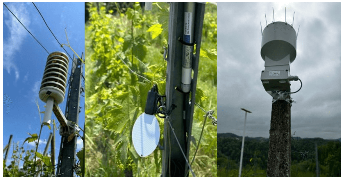
IoT wineyard monitoring system
Source: Smart Villages Network
Last update: 23-09-25
The digital solution is a vineyard monitoring system, which consists of sensor infrastructure to measure different weather and viticultural parameters: Soil Moisture Sensor, Rain Meter, Leaf Wetness Sensor and Outdoor Microclimate Sensor which collects data for temperature, relative humidity, and air pressure. These sensors communicate with a gateway located on the top of a hill using LoRaWAN technology. The data collection model is implemented on the ThingsBoard platform, where sensor data is stored and accessible via an application programming interface.